Heritage Article:
Recent Heritage Article
Showing posts with label Wildlife of Bangladesh. Show all posts

Madhabkunda waterfall of Bangladesh

Madhabkunda waterfall
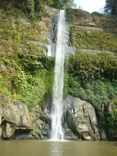
Madhabkunda waterfall of Bangladesh

Madhabkunda  is the largest waterfall in Bangladesh and it is a great country to be in situated Barlekha thana (subdistrict) in Moulvi Bazar District, Sylhet Division. The waterfall is one of the most attractive tourist spots in Bangladesh. Lots of tourists and picnic parties come to Madhabkunda every day for their enjoyment. Fall of million tons of water form 200 ft. height. Big bolder of stones and the black stones with green leafy trees and the sound of waterfall is giving a shape of care in Madhabkunda.It is Located at 24°38′21″N 92°13′16″E and about 200 ft (61 m) high. It is about five km away from Dakshinbagh railway station on the Kulaura-Shabajpur track (see Akhaura-Kulaura-Chhatak Line), and 350 km from Dhaka city.Visitors can visit Madhabkunda either from Sylhet or Moulvibazar by road, or from Kulaura Junction by train.The journey to Madhabkunda itself is exotic. On the way visitors can see the greenish beauty of tea garden, the hills and the zigzag road through the hills. Rubber and lemon plantations form a beautiful ladscape.
Lawachara National Park of Bangladesh

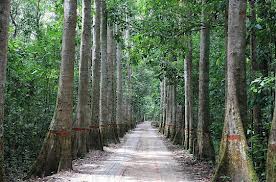
Lawachara National ParkLawachara National Park of Bangladesh
                                    Lawachara National Park of Bangladesh

Location: Maulvi Bazar District, Sylhet Division, Bangladesh
Nearest city: Srimonga
Area: 1250 hectares
Established:199
Lawachara National Park  is a major national park and nature reserve in Bangladesh. The park is located at Kamalganj Upazila, Maulvi Bazar District in the northeastern region of the country. It is located within the 2,740 ha (27.4 km2) West Bhanugach Reserved Forest.Lawachara National Park covers approximately 1,250 ha (12.5 km2) of semi-evergreen forests of the Tropical and subtropical coniferous forests Biome and mixed deciduous forests of the Tropical and subtropical moist broadleaf forests Biome. The land was declared a national park by the Bangladesh government on July 7, 1996 under the Wildlife Act of 1974.Lawachara is about 160 km (99 mi) northeast of Dhaka and 60 km (37 mi) from Sylhet. It is 8 kilometres (5.0 mi) from the town of Srimongal.The terrain of Lawachara is undulating with scattered 10 to 50 m (33 to 160 ft) hillocks. Locally known as tila, the hillocks are primarily composed of Upper Tertiary soft sandstone. The park is crossed by numerous sandy-bedded streams (locally known as nallah), one of which is the Lawachara tributary, from which the park derived its name.[3] The soil of Lawachara is alluvial brown sandy clay loam to clay loam dating from the Pliocene epoch. Shallow depressions filled with water (haor wetlands) are also a feature of the region as the low-lying areas are often subject to flooding.The climate of Lawachara is generally pleasant to warm, averaging at 26.8 °C (80.2 °F) in February to 36.1 °C (97.0 °F) in June. The humidity is high throughout the year, and Lawachara experiences frequent rains with occasional cyclonic storms.


Bhawal National Park of Bangladesh

Bhawal National Park
Bhawal National Park of Bangladesh
Bhawal National Park was established and maintained as a National Park in 1974; it was officially declared in 1982 under the Wildlife Act of 1974. It is located in Gazipur, Dhaka Division of Bangladesh, approximately 40 km north of Dhaka city, only 20 km drive from Gazipur and 20 km from Kapasia. The core area of the park covers 940 hectares but extends to 5,022 ha of surrounding forest. Its purpose is to protect important habitats as well as to provide opportunities for recreation. It has been kept under IUCN Management Category V, as a protected landscape. The most common flora is the unique coppice sal forest. The area was noted for peacocks, tiger, leopard, black panther, elephant, clouded leopard and sambar deer. However much of the wildlife had disappeared and only a few species remain. Also, most of the forest has been denuded and is now occupied by forestry companies or displaced people.Most of this area was covered by forests fifty years ago and the dominant species was Sal (Shorea robusta). Illegal deforestation has left only 600 km² of the forest and new trees and woodlands have been planted.The park has 220 plant species, including 43 different tree species, 19 shrubs, 3 palms, 27 grasses, 24 vines, and 104 herbs. The wildlife in the park includes 13 mammals, 9 reptiles, 5 birds and 5 amphibians. In addition the Forest Department has recently introduced peacocks, deers, pythons, and cat fish

Sundarbans Wildlife of Bangladesh

Sundarbans Wildlife
Sundarbans Wildlife of Bangladesh
The Sundarbans  is the largest single block of tidal halophytic mangrove forest in the world. The Sundarbans is a UNESCO World Heritage Site covering parts of Bangladesh and the Indian state of West Beng
The name Sundarban can be literally translated as "beautiful forest" in the Bengali language (Shundor, "beautiful" and bon, "forest"). The name may have been derived from the Sundari trees (the mangrove species Heritiera fomes) that are found in Sundarbans in large numbers. Alternatively, it has been proposed that the name is a corruption of Samudraban Shomudrobôn "Sea Forest") or Chandra-bandhe (name of a primitive tribe). However, the generally accepted view is the one associated with Sundari tree
Two-third of the Sundarbans is in Bangladesh and the remaining third in West Bengal, India. The Sundarbans National Park is a National Park, Tiger Reserve, and a Biosphere Reserve located in the Sundarbans delta in the Indian state of West Bengal. Sundarbans South, East and West are three protected forests in Bangladesh. This region is densely covered by mangrove forests, and is one of the largest reserves for the Bengal tiger.The Sundarban forest lies in the vast delta on the Bay of Bengal formed by the super confluence of the Padma, Brahmaputra and Meghna rivers across southern Bangladesh. The seasonally flooded Sundarbans freshwater swamp forests lie inland from the mangrove forests on the coastal fringe. The forest covers 10,000 km2. of which about 6,000 are in Bangladesh. It became inscribed as a UNESCO world heritage site in 1997. The Sundarbans is estimated to be about 4,110 km², of which about 1,700 km² is occupied by waterbodies in the forms of river, canals and creeks of width varying from a few meters to several kilometers.

 
Copyright © 2013. Heritage of Bangladesh