Heritage Article:
Recent Heritage Article
Showing posts with label Heritage of bangladesh. Show all posts

Patul: Natural place of Natore District

Patul at Natore

natural place patul
Natural place Patul

Original Name: Pātul
Geographical Location: Natore Zl, Rajshahi Div, Bangladesh, Asia

Geographical Coordinates: 24° 29' 0" North, 89° 0' 0" East

Detailed map of Patul and near places:
Welcome to the Patul google satellite map! This place is situated in Natore Zl, Rajshahi Div, Bangladesh, its geographical coordinates are 24° 29' 0" North, 89° 0' 0" East and its original name (with diacritics) is Pātul. See Patul photos and images from satellite below, explore the aerial photographs of Patul in Bangladesh. Patul hotels map is available on the target page linked above.

PATUL MAP
PATUL MAP

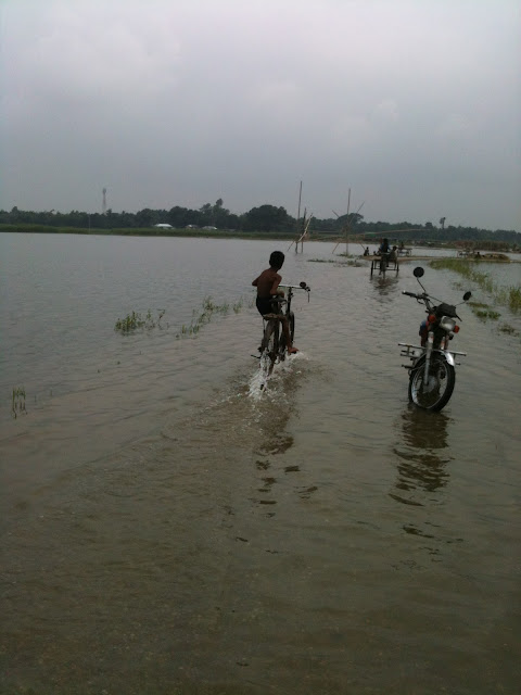
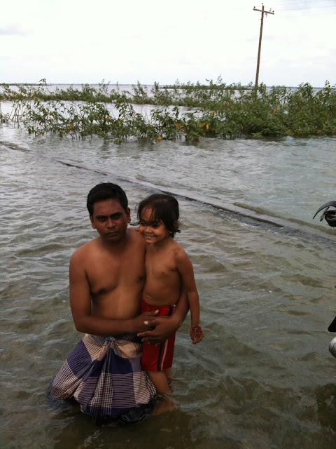
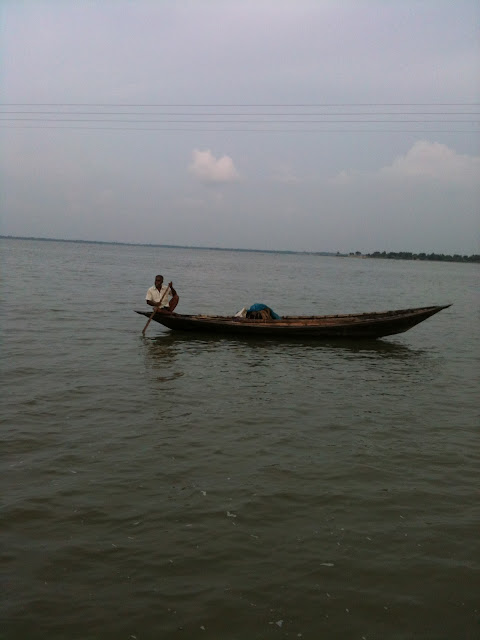
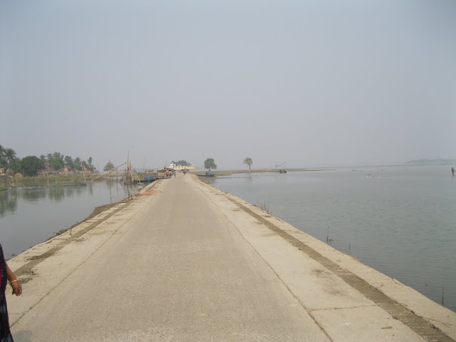
Patul is natural place of Natore District. It has a great natural resoures. A part of singra cholonbill river is the main attraction of patul. A road goes with full of waters in both sides. A visitor can walk and run in this road with water. It's a long road. Many tourist swim with their family. It's a tourist place. It is situated in village and villege's nature is so wonderful. Many tourist come here and selibrate their party. There are many fishers fishes fish. There are many fisher's boats and tour boats looking there. Some pics are available below-

Patul of Natore
Patul of Natore

Patul of Natore
Patul of Natore

Patul of Natore
Patul of Natore

Patul of Natore
Patul of Natore

Patul of Natore
Patul of Natore

Patul of Natore
Patul of Natore

Patul of Natore
Patul of Natore

Cox's Bazar of Bangladesh

Cox's Bazar

Cox's Bazar of Bangladesh


Country: Bangladesh
Administrative District: Cox's Bazar District
Area:  City 6.85 km2 (2.64 sq mi)
Elevation: 3 m (10 ft)
Population: (2007 est.)Total population represents population in city and metro represents entire district.
City: 51,918
Density: 7,579.27/km2 (19,630.2/sq mi)
Metro: 120,480
Time zone: BST (UTC+6)


Cox's Bazar is a town, a fishing port and district headquarters in Bangladesh. It is known for its wide and long sandy beach which is considered by many as the world's longest natural sandy sea beach, The beach in Cox's Bazar is an unbroken 125 km sandy sea beach with a gentle slope. It is located 150 km south of the industrial port Chittagong. Cox’s Bazar is also known by the name Panowa, whose literal translation means "yellow flower." Its other old name was "Palongkee".
The modern Cox's Bazar derives its name from Captain Hiram Cox (died 1799), an officer serving in British India. An officer of the British East India Company, Captain Cox was appointed Superintendent of Palongkee outpost after Warren Hastings became Governor of Bengal. Captain Cox was specially mobilised to deal with a century-long conflict between Arakan refugees and local Rakhains. He embarked upon the mammoth task of rehabilitating refugees in the area and made significant progress. A premature death took Captain Cox in 1799 before he could finish his work. To commemorate his role in rehabilitation work, a market was established and named Cox's Bazar ("Cox's Market") after him.
Today, Cox's Bazar is one of the most-visited tourist destinations in Bangladesh. It has yet to become a major international tourist destination, and has no international hotel chains, due to lack of publicity and transportation.
Cox's Bazar of Bangladesh

Story of Cox's Bazar
The greater Chittagong area, including Cox's Bazar, was under the rule of Arakan kings from the early 9th century until its conquest by the Mughals in 1666 AD. When the Mughal Prince Shah Shuja was passing through the hilly terrain of the present-day Cox’s Bazar on his way to Arakan, he was attracted to its scenic and captivating beauty. He commanded his forces to camp there. His retinue of one thousand palanquins stopped there for some time. A place named Dulahazara, meaning "one thousand palanquins," still exists in the area. After the Mughals, the place came under the control of the Tipras and the Arakanese, followed by the Portuguese and then the British.
The name Cox's Bazar/Bazaar originated from the name of a British East India Company officer, Captain Hiram Cox, who was appointed as the Superintendent of Palonki (today's Cox's Bazar) outpost. He succeeded Warren Hastings, who became the Governor of Bengal following the British East India Company Act in 1773. Cox was mobilised to deal with a century-long conflict between Arakan refugees and local Rakhine people at Palonki. The Captain had rehabilitated many refugees in the area, but had died (in 1799) before he could finish his work. To commemorate that, a market was established and named after him, called Cox's Bazar (market of Cox). Cox's Bazar then was first established in 1854 and became a municipality in 1869.
After the Sepoy Mutiny (Indian Rebellion of 1857) in 1857, the British East India Company was highly criticised and questioned on humanitarian grounds, specially for its opium trade monopoly over the Indian Sub-Continent. However, after its dissolution on 1 January 1874, all of the company's assets including its Armed Forces were acquired by the British Crown. After this historic take over, Cox's Bazar was declared a district of the Bengal Province under the British Crown.
Cox's Bazar of Bangladesh

After the end of British rule in 1947, Cox's Bazar became part of East Pakistan. Captain Advocate Fazlul Karim, the first Chairman (after independence from the British) of Cox's Bazar Municipality, established the Tamarisk Forest along the beach. He wanted to attract tourists as well as to protect the beach from tidal waves (tsunami). He donated much of his father-in-law’s and his own lands as sites for constructing a Public Library and a Town Hall. He was inspired to build Cox's Bazar as a tourist spot after seeing beaches of Bombay and Karachi, and was a resort pioneers in developing Cox's Bazar as a destination. He founded a Maternity Hospital, the Stadium and the drainage system by procuring grants from the Ford Foundation and Rockefeller Foundation through correspondence. T. H. Matthews, the principal of the Dacca Engineering College (1949~1954), was a friend who had helped him in these fundraising efforts. Engineer Chandi Charan Das was the government civil engineer who had worked on all these projects. In 1959 the municipality was turned into a town committee.
In 1961 the erstwhile Geological Survey of Pakistan initiated investigation of radioactive minerals like monazite around the Cox's Bazar sea-beach area.
Cox's Bazar of Bangladesh

In 1971, Cox's Bazar wharf was used as a naval port by the Pakistan Navy's gunboats. This and the nearby airstrip of the Pakistan Air Force were the scene of intense shelling by the Indian Navy during the Bangladesh Liberation War. During the war, Pakistani soldiers killed many people in the town, including eminent lawyer Jnanendralal Chowdhury. The killing of two freedom fighters named Farhad and Subhash at Badar Mokam area is also recorded in history.
Cox's Bazar of Bangladesh

After the independence of Bangladesh, Cox's Bazar started to get administrative attention. In 1972 the town committee of Cox's Bazar was turned into a municipality. In 1975, The Government of Bangladesh established a pilot plant at Kalatali. Later, in 1984 Cox's Bazar subdivision was promoted to a district, and five years later (in 1989) the Cox's Bazar municipality was elevated to B-grade. In 1994 (jobs) the Marine Fisheries and Technology Station (MFTS) was established at Cox's Bazar. MFTS is a research station of Bangladesh Fisheries Research Institute (BFRI) headquartered in Mymensingh. The station covers a land area of four hectares and contains five laboratories. In April 2007 Bangladesh got connected to the submarine cable network as a member of the SEA-ME-WE-4 Consortium, as Cox's Bazar was selected as the landing station of the submarine cable. In September 2012 the municipality was the site of the Cox's Bazar and Ramu riots, where local Muslims attacked the Buddhist community over an alleged Quran desecration posted to Facebook.
Mosque Baba Adam of Bangladesh

Mosque Baba Adam

Mosque Baba Adam of Bangladesh

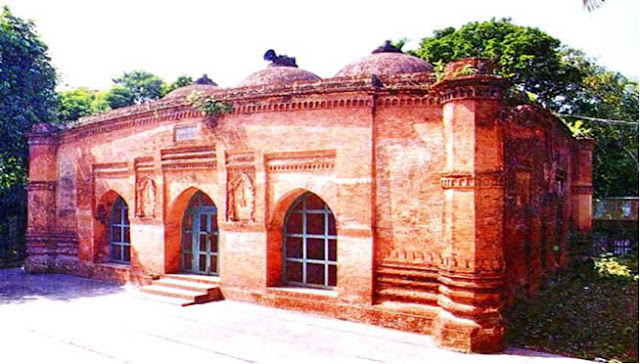
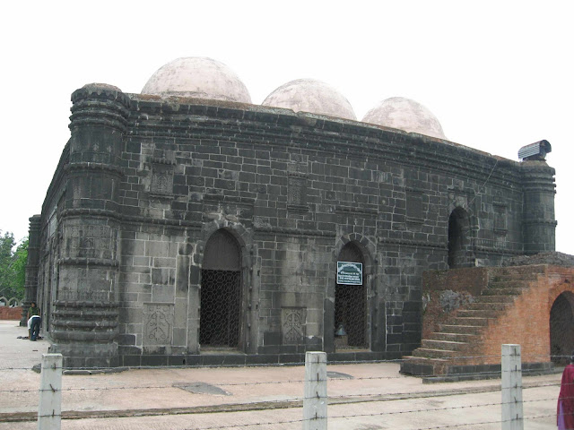
A slightly later date the elegant 6-domed mosque (13m x 11m) sq meters of Baba Adam in Rampal near Dhaka was erected by your Malik Kafur during the reign of the last Ilyas Shahi Sultan, Jalauddin Fateh Shah in 1483 AD. It displays the same characteristic features of the period such as the faceted octagonal turrets at 4 corners, the curved cornice. The one facade and 3 mihrabs relieved richly with beautiful terracotta floral and hanging patterns.

Mahasthangarh of Bangladesh

Mahasthangarh

Mahasthangarh of Bangladesh


Mahasthangarh is considered the oldest archaeological site of the county. It is located at a distance of 18 km north or Bogra town on the western bank of the Karatoa river. The spectacular site is an imposing landmark in the area. having a long fortified enclosure. Beyond the fortified area, other ancient ruins fan out within a semicircle of about 8 km radius. Several isolated mounds, the local names of which are  Govinda Bhita  Temple,  Khodia Pathar  Mound,  Mankalir Kunda ,  Parsuramer Bedi ,  Jiyat Kunda  etc. surround the fortified city. This 3rd century B.C. archaeological site is still held to be of great sanctity by the Hindus. Every year (mid-April) and once every 12 years (in December) thousands of Hindu devotees join the bathing ceremony on the bank of the Karatoa river.

Hussaini Dalan of Bangladesh

Hussaini Dalan

Hussaini Dalan of Bangladesh
Hussaini Dalan a Shiite shrine in the old part of the city of DHAKA, attributed to the Mughal Period. It is a common practice among the Shia community to build edifices to commemorate the martyrdom of al-Husain, at the battle of Karbala in Iraq on the tenth day of Muharram 61 AH (10 October 680 AD). The building seems to have been originally erected by one Sayyid Murad during the governorship of SHAH SHUJA, who, although himself a Sunni, was eager to preserve and patronise Shiite institutions. Traditions relate that Sayyid Murad, having seen al-Husain in a vision erecting a tazia khana (house of mourning), was inspired to raise the building, which he named Hussaini Dalan. The original building may have been a small structure, expanded to its present form in later times. The EAST INDIA COMPANY repaired it in 1807 and 1810, and a portion of the building was reconstructed after the earthquake of 1897.

Paharpur of Bangladesh

Paharpur

Paharpur of Bangladesh

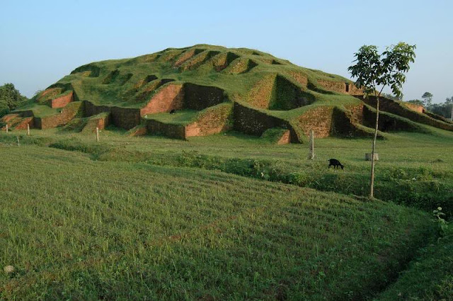
Paharpur is treated as the Largest Buddhist Seat of Learning of South Asia. It is a small village, 5 km west of Jamalganj in the greater Rajshahi district, where the remains of the most important and the largest known monastery south of the Himalayas has been excavated. This 7th century AD archaeological find covers an area of approximately 11 hectare. The entire establishment, occupying a Quadrangular court, measures more than 300 meters and varies from 3.5 to 4.5 meters in height with an elaborate gateway complex on the north, there are 45 cells on the north and 44 in each of the other three sides, with a total number of 177 rooms.

Star Mosque of Bangladesh

Star Mosque

Star Mosque of Bangladesh

Star mosque, a 19th century establishment, is a very beautiful mosque of the city situated at Armanitola, in the old part of Dhaka City. In faultless Mughal style architecture, it is a five -dome mosque with hundreds of big and small twinkling stars as surface decorations. The stars have been created by setting pieces or chinaware on white cement. Seen from the front and from far it looks as if it were shining above the surface of the earth. The inside or the mosque is even more beautiful than the outside, with a lovely mosaic floor and excellent tiles with many floral patterns set on the walls, all in complete harmony.

Sonargaon of Bangladesh

Sonargaon

Sonargaon of Bangladesh

Sonargaon's importance in the pre-Muslim period is borne out by its ancient name of  Suvarnagrama (the golden village), from which it is obvious how the Muslim version of the name is derived,as well as by the existence of Langalbandh and Panchamighat, the two traditional under Ghiyasuddin Bahadur Shah, and after his fall it was the headquarters of the eastern province of Bengal under the Tughlaqs till 1338. Sonargaon emerged as the capital of an independent Sultanate under Fakhruddin Mubarak Shah (1338-1349). In the late nineteenth and early twentieth century Panam Nagar was developed in a part of holy bathing places of the Hindus, in this tract of land on the west bank of the old Brahmaputra. Sonargaon rose to be the seat of an independent ruler medieval Sonargaon.

Baitul Mukarram Mosque of Bangladesh

Baitul Mukarram Mosque

Baitul Mukarram Mosque of Bangladesh

It is the National Mosque of Bangladesh. Its construction began on 1960, and has been going on in phases. Architect T Abdul Hussain Thariani was commissioned to design the mosque complex. The plan included shops, offices, libraries and parking areas within the complex. The design of the mosque reflects the architecture of the period as can be seen from the use of a white and almost cube-form for the main building. A Mosque without a dome over the roof of its main prayer hall must have been a unique experiment. The main building is eight storied and 33 meters high from the ground level. The area of the main prayer hall is 2464 SQ meters with a mezzanine floor of 171 SQ metres at the eastern side. Verandas surround the hall on three of its four sides. The  mihrab  of the hall is rectangular instead of semi-circular. The Baitul Mukarram mosque is modern in its architectural style. It has found its place in the hearts of the Muslims because of the resemblance of its form to the Holy Kaaba at Makkah.

Mainamati of Bnagladesh

Mainamati

Mainamati of Bnagladesh

It is called the Seat of Lost Dynasties. About 8 km to the west of Comilla town, situated 114 km southeast of Dhaka, lies a range of low hills known as the Mainamati-Lalmai ridge, which was an extensive centre of Buddhist culture. On the slopes or these hills lie scattered a treasure of information about the early Buddhist civilization (7th-12th Century AD.). At Salban in the middle or the ridge, excavations have laid bare a large Buddhist  Vihara  (monastery) with an imposing central shrine. It has revealed valuable information about the rule of the Chandra and Deva dynasties which Flourished here from the 7th to the 12th century AD. The whole range of hillocks runs for about 18 km and is studded with more than 50 sites. A site museum houses the archaeological finds which include terra cotta plaques, bronze statues and caskets, coins, jewellery, utensils, pottery and  votive stupas  embossed with Buddhist inscriptions.

Chhota Sona Masjid of Bangladesh

Chhota Sona Masjid

Chhota Sona Masjid of Bangladesh
One of the most graceful monuments of the Sultanate period is the  Chhota Sona Masjid  or Small Golden Mosque at Gaur in Rajshahi. Built by one Wali Muhammad during the reign of Sultan Alauddin Husain Shah (1493-1519), it was originally roofed over with 15 gilded domes including the 3 ChauchaIqa domes in the middle row, from which it derives its curious name.

Shat Gombuj Mosque of Bangladesh

Shat Gombuj Mosque

Shat Gombuj Mosque of Bangladesh

Among the many surviving monuments of the Khan Jahan Ali style, undoubtedly the most magnificent and largest brick mosque in Bangladesh is the Shat Gombuj. It is situated in Bagerhat district. For outstanding architectural value. the World Heritage Committee of UNESCO inscribed Bagerhat in the World Heritage list and it got the status of the second World Heritage site in Bangladesh after Paharpur. Out of today's surviving mosques, the Shat Gombuj Mosque is the most magnificent and certainly the largest brick mosque surviving in Bangladesh. Its name, meaning '60 domes', is misleading as in reality, it is roofed over with 77 small domes supported by a forest of slender columns covering a large prayer hall and giving it the appearance of a medieval church crypt. At sunrise when the rays of the sun penetrate the eastern entrances, the interior comes to life. There is little adornment to this building other than the carved stone decoration to the central  mihrab  at the western end of the prayer hall. The exterior facades, with slightly 'battered' walls, have discernible curving cornices a concession to the local style.

National Parliament of Bnagladesh

National Parliament

National Parliament of Bnagladesh

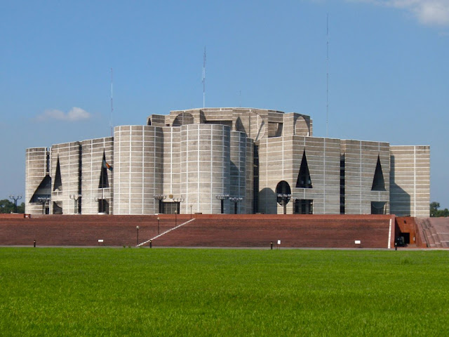
It is one of the most majestic public buildings in Bangladesh. The National Parliament complex is located at Sher-e-Bangla Nagar of Dhaka city. The National Parliament Building is an architectural masterpiece for which the nation can be said to be justifiably proud.The decision to construct the National Parliament Complex at Dhaka was originally taken in 1959. Louis I Kahn. one of the greatest architects of the time was initially selected for designing the complex. which would include the National Parliament Building. Hostels for members of parliament. ministers and secretaries. hospitality halls and communally buildings.All linked by roads and walkways and surrounded by attractive gardens and lakes. The main characteristic of the building is its monumentally.The mass of concrete lined with marble strips, the outer wall punctuate by pure geometrical openings and the dominating circular and rectangular concrete masses impart a supreme monumentality to the building quite suited to its noble function.

National Museum of Bangladesh

National Museum

National Museum of Bangladesh

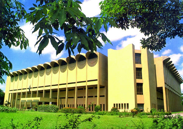
The National Museum was established at dhaka in AD 1913.It has been renamed as the National Museum and was shifted to its new building at Shahbag in 1983. It is a four storied building and has forty galleries under four departments, namely, Natural History, History and Classical Art, Ethnography and Decorative Art and Contemporary Art and world Civilization.

National Memorial of Bangladesh

National Memorial

National Memorial of Bangladesh

The National Memorial at Savar is a symbol of the nation's respect for the martyrs of the war of Liberation. It is built with Concrete, but made of blood. IT stands 150 feet tall, but every martyr it stands for stands so much taller. It is an achievement the dimensions of which can be measured but it stands for an achievement which is immeasurable. It stands upright for the millions of martyrs who laid their lives so that we may stand upright, in honour and dignity, amongst the nations of the world. Most prominently visible is the 150 feet tower that stands on a base measuring 130 feet wide.

Lalbagh Fort of Bangladesh

Lalbagh Fort

Lalbagh Fort of Bangladesh

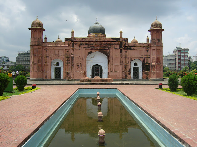
Lalbagh Fort (also known as: Fort Aurangabad) is an incomplete Mughal palace fortress at the Buriganga River in the southwestern part of Dhaka, Bangladesh. Construction was commenced in 1678 by Prince Muhammad Azam during his 15-month long vice-royalty of Bengal, but before the work could complete, he was recalled by Aurangzeb. His successor, Shaista Khan, did not complete the work, though he stayed in Dhaka up to 1688. His daughter bibi pari (Lady Fairy) died here in 1684 and this led him to consider the fort to be ominous.

Ahsan Manzil of Bangladesh

Ahsan Manzil

Ahsan Manzil of Bangladesh

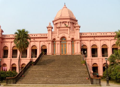
Ahsan Manzil  was the official residential palace and seat of the Dhaka Nawab Family. It is situated on the banks of the Buriganga River in Bangladesh. The palace is now a museum.

Tajhat Rajbari of Bangladesh

Tajhat Rajbari

Tajhat Rajbari of Bangladesh

Tajhat is a historical place of Bangladesh, located near Lalbagh, Rangpur. It has a nice Jamidarbari (Palace) which in 2005 was turned into a museum. This museum is about 10 mins drive from Rangpur town, near Lalbagh. The Museum was inaugurated on March 20, 2005, by the Government of Bangladesh Minister for Cultural Affairs, Begum Selima Rahman and Secretary Mr. Mahmudul Masud. Dr. Alain Labrique of the Johns Hopkins University also made some invited remarks. The palace in Tajhat, commonly known as Tajhat Rajbari was built by Maharaja Kumar Gopal Lal Roy in the beginning of the 20th century. He was a descendent of a Hindu khatari who emigrated from Punjab. He was a jeweler by profession. It is believed that from the conspicuous appearance of his Taj or jeweledcrown his estate derived the name of Tajhat. From the name of his estate, the area is known as Tajhat.

Shaheed Minar of Bangladesh

Shahid Minar

Shaheed Minar of Bangladesh


The Shaheed Minar is a national monument in Dhaka, Bangladesh, established to commemorate those killed during the Language Movement demonstrations of 1952.On February 21, 1952, dozens of students and political activists were killed when the Pakistani police force opened fire on Bengali protesters who were demanding equal status to their native tongue, Bangla. The massacre occurred near Dhaka Medical College and Ramna Park in Dhaka. A makeshift monument was erected on February 23 by students of University of Dhaka and other educational institutions, but soon demolished on February 26 by the Pakistani police force.The Language Movement gained momentum and after a long struggle, Bangla was given equal status as Urdu. To commemorate the dead, the Shaheed Minar was designed and built by Hamidur Rahman, a Bangladeshi sculptor. The monument stood until the Bangladesh Liberation War in 1971, when it was demolished completely during Operation Searchlight. After Bangladesh gained independence, it was rebuilt .Today, the Shaheed Minar is the centre of cultural activities in Dhaka. Every year, the Language Movement is remembered at the monument.
 
Copyright © 2013. Heritage of Bangladesh